干旱区研究 ›› 2021, Vol. 38 ›› Issue (2): 314-326.doi: 10.13866/j.azr.2021.02.03
邓小进( ),井长青(),郭文章,陈宸,付皓宇
收稿日期:2020-06-04
修回日期:2020-08-28
出版日期:2021-03-15
发布日期:2021-04-25
通讯作者:
井长青
作者简介:邓小进(1986-),女,硕士研究生,主要从事草地遥感研究. E-mail:基金资助:
DENG Xiaojin(),JING Changqing(),GUO Wenzhang,CHEN Chen,FU Haoyu
Received:2020-06-04
Revised:2020-08-28
Online:2021-03-15
Published:2021-04-25
Contact:
Changqing JING
摘要:
地表反照率变化影响地表辐射收支与能量平衡,从而对区域和全球气候产生影响。以准噶尔盆地为研究对象,利用MODIS卫星遥感数据产品MOD09A1反演地表短波反照率,结合气象数据和植被指数分析准噶尔盆地2001—2018年荒漠草地地表反照率时空变化特征及其影响因素。结果表明:准噶尔盆地地表反照率空间分布地域差异明显,地表反照率年均值为0.303,整体呈东北高、西南低的特点;其年际变化速率呈减少趋势,平均每年为1.4×10⁻⁴,减少面积约占总面积的52.8%;四季空间分布变化明显,春、夏、秋三季空间分布相似,冬季值最高(0.551),夏季最低(0.203)。准噶尔盆地东北缘的阿尔泰山地表反照率年内变化较为剧烈;生长季归一化植被指数(NDVI)值大小为:夏季>秋季>春季。准噶尔盆地整体地表反照率与NDVI呈负相关,大部分区域与平均气温呈负相关,与降水呈正相关,且相关性大小依次为气温>NDVI>降水。MODIS反演结果与地面实测值之间存在显著的相关性(R2=0.8908,P<0.01),均方根误差为0.014。为了解准噶尔盆地陆面特征,客观评价全球气候变化下干旱区陆面变化及其正负反馈响应机制提供一定的理论依据。
邓小进,井长青,郭文章,陈宸,付皓宇. 准噶尔盆地地表反照率时空变化特征及其影响因素分析[J]. 干旱区研究, 2021, 38(2): 314-326.
DENG Xiaojin,JING Changqing,GUO Wenzhang,CHEN Chen,FU Haoyu. Spatio-temporal variation characteristics of surface albedo and analysis of influential factors in the Junggar Basin[J]. Arid Zone Research, 2021, 38(2): 314-326.
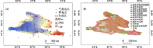
图1
准噶尔盆地地理位置(a)和植被类型分布示意图(b)"

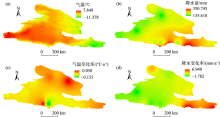
图2
2001—2018年准噶尔盆地年均温度、降水量及年际变化趋势"

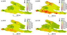
图3
准噶尔盆地春、夏、秋季及全年年均植被NDVI空间分布"

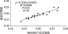
图4
2017年8月MODIS反演与地面观测值反照率散点图"

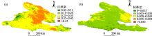
图5
准噶尔盆地年均地表反照率和年均地表反照率标准差"


图6
准噶尔盆地春、夏、秋、冬四季地表反照率年平均分布"

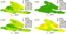
图7
准噶尔盆地春、夏、秋、冬地表反照率年平均标准差"

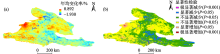
图8
准噶尔盆地年均地表反照率变化速率和显著性变化空间分布"

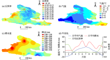
图9
2015年准噶尔盆地地表反照率、气温、降水及年变化关系"

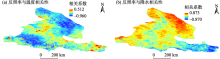
图10
2001—2018年准噶尔盆地地表短波反照率与温度、降水量的相关系数空间分布"


图11
准噶尔盆地反照率与植被指数NDVI相关系数和年变化"

| [1] | Planque C, Carrer D, Roujean J L. Analysis of MODIS albedo changes over steady woody covers in France during the period of 2001-2013[J]. Remote Sensing of Environment, 2017,191(15):13-29. |
| [2] | 孙菽芬. 陆面过程的物理、生化机理和参数化模型[M]. 北京: 气象出版社, 2005. |
| [ Sun Shufen. Physical, Biochemical Mechanism and Parametric Model of Land Surface Process[M]. Beijing: China Meteorological Press, 2005. ] | |
| [3] | 肖登攀, 陶福禄, Moiwo Juana P. 全球变化下地表反照率研究进展[J]. 地球科学进展, 2011,26(11):1217-1224. |
| [ Xiao Dengpan, Tao Fulu, Moiwo Juana P. Research progress on surface albedo under global change[J]. Advances in Earth Science, 2011,26(11):1217-1224. ] | |
| [4] | Liang S L, Wang K, Zhang X, et al. Review on estimation of land surface radiation and energy budgets from ground measurement, remote sensing and model simulations[J]. IEEE Journal of Special Topics in Applied Earth Observations and Remote Sensing, 2010,3(3), 225-240. |
| [5] | Li Q P, Ma M G, Wu X D, et al. Snow cover and vegetation-induced decrease in global albedo from 2002 to 2016[J]. Journal of Geophysical Research: Atmospheres, 2018,123(1):124-138. |
| [6] | 王鸽, 韩琳. 地表反照率研究进展[J]. 高原山地气象研究, 2010,30(2):79-83. |
| [ Wang Ge, Han Lin. Progress in the research of surface albedo[J]. Plateau and Mountain Meteorology Research, 2010,30(2):79-83. ] | |
| [7] | 除多, 马伟强, 扎西顿珠. 藏北那曲地区地面与MODIS反演的地表反照率对比分析[J]. 遥感技术与应用, 2015,30(5):908-916. |
| [ Chu Duo, Ma Weiqiang, Zhaxi Dunzhu. Land surface albedo in the north Tibetan Plateau from ground observations and MODIS[J]. Remote Sensing Technology and Application, 2015,30(5):908-916. ] | |
| [8] | 王介民, 高峰. 关于地表反照率遥感反演的几个问题[J]. 遥感技术与应用, 2004,19(5):295-300. |
| [ Wang Jiemin, Gao Fen. Discussion on the problems on land surface albedo retrieval by remote sensing data[J]. Remote Sensing Technology and Application, 2004,19(5):295-300. ] | |
| [9] | 庄晓翠, 李博渊, 张林梅, 等. 新疆阿勒泰地区冬季大到暴雪气候变化特征[J]. 干旱区地理, 2013,36(6):1013-1022. |
| [ Zhuang Xiaocui, Li Boyuan, Zhang Linmei, et al. Heavy snowstorm characteristics of climatic change in winter in Altay Xinjiang[J]. Arid Land Geography, 2013,36(6):1013-1022. ] | |
| [10] | 吴徐燕, 杨德保, 王式功, 等. 近50 a中国大陆无雨日的时空变化特征分析[J]. 干旱区地理, 2011,34(4):596-603. |
| [ Wu Xuyan, Yang Debao, Wang Shigong, et al. Temporal and spatial characteristic of rainless days in mainland China in recent 50 years[J]. Arid Land Geography, 2011,34(4):596-603. ] | |
| [11] | 吴倩倩. 青藏高原MODIS地表反照率的分析与应用[D]. 南京: 南京信息工程大学, 2016. |
| [ Wu Qianqian. Analysis and Application of MODIS Albedos over Tibetan Plateau[D]. Nanjing: Nanjing University of Information Science & Technology, 2016. ] | |
| [12] | 曹晓云. 基于MODIS的青藏高原地表反照率时空变化研究[D]. 南京: 南京信息工程大学, 2018. |
| [ Cao Xiaoyun. Spatial and Temporal Change of Surface Albedo over the Tibetan Plateau based on MODIS[D]. Nanjing: Nanjing University of Information Science & Technology, 2018. ] | |
| [13] | 李喜佳. 基于遥感观测的全球地表反照率时空变化研究[D]. 长春: 东北师范大学, 2019. |
| [ Li Xijia. Spatiotemporal Changes of Global Land Surface Albedo from Remote Sensing Observations[D]. Changchun: Northeast Normal University, 2019. ] | |
| [14] | Liang S L, Zhao X, Liu S H, et al. A long-term global land surface satellite (GLASS) data-set for environmental studies[J]. International Journal of Digital Earth, 2013,1(6):5-33. |
| [15] | Karlsson K, Anttila K, Trentmann J, et al. CLARA-A2: The second edition of the CM SAF cloud and radiation data record from 34 years of global AVHRR data[J]. Atmospheric Chemistry and Physics, 2017,17(9):5809-5828. |
| [16] | 王鸽. 1982—2000年中国区域地表反照率时空分布特征[J]. 高原气象, 2010,29(1):146-151. |
| [ Wang Ge. The distribution of surface albedo in China during 1982-2000[J]. Plateau Meteorology, 2010,29(1):146-151. ] | |
| [17] | 王鸽, 韩琳, 姬光杰. 1982—1998年中国不同地区地表反照率变化原因初探[J]. 重庆师范大学学报: 自然科学版, 2011,28(4):79-83. |
| [ Wang Ge, Han Lin, Ji Guangjie. Research of the reason for variations of surface albedo in different areas in China from 1982 to 1998[J]. Journal of Chongqing Normal University (Natural Science), 2011,28(4):79-83. ] | |
| [18] | 魏文寿, 何清, 刘明哲, 等. 准噶尔盆地的气候变化与荒漠环境研究[J]. 中国沙漠, 2003,23(2):101-105. |
| [ Wei Wenshou, He Qing, Liu Mingzhe, et al. Climate change and the desert environment in Junggar Basin, Xinjiang, China[J]. Journal of Desert Rsesarch, 2003,23(2):101-105. ] | |
| [19] | 秦大河. 气候变化科学与人类可持续发展[J], 地理科学进展, 2014,33(7):874-883. |
| [ Qin Dahe. Climate change science and human sustainable development[J]. Progress in Geography, 2014,33(7):874-883. ] | |
| [20] | 陈乙实, 孙海荣, 李娜娜, 等. 绵羊放牧绢蒿荒漠草地植物群落多样性及其环境解释[J]. 草业学报, 2019,28(11):1-11. |
| [ Chen Yishi, Sun Hairong, Li Nana, et al. Plant community diversity in grazed Seriphidium semidesert glassland and its relationships with environmental factors[J]. Acta Prataculturae Sinica, 2019,28(11):1-11. ] | |
| [21] | 姚彤, 张强. 我国北方不同类型下垫面地表反照率特征[J]. 物理学报, 2014,63(8):460-468. |
| [ Yao Tong, Zhang Qiang, Study on land-surface albedo over different types of underlying surfaces in North China[J]. Acta Physica Sinica, 2014,63(8):460-468. ] | |
| [22] | 安颖颖, 孟宪红, 赵林, 等. GLASS、MODIS和GlobAlbedo反照率产品在青藏高原典型高寒草地的适用性评估[J]. 高原气象, 2019,38(1):88-100. |
| [ An Yingying, Meng Xianhong, Zhao Lin, et al. Evaluation the applicability of albedo products of GLASS, MODIS and GlobAlbedo under the alpine meadow over the Qinghai-Tibetan Plateau[J]. Plateau Meteorology, 2019,38(1):88-100. ] | |
| [23] | 徐田利, 邬光剑, 张学磊, 等. 基于MODIS数据的青藏高原冰川反照率时空分布及变化研究[J]. 冰川冻土, 2018,40(5):875-883. |
| [ Xu Tianli, Wu Guangjian, Zhang Xuelei, et al. Albedo on glaciers in the Tibetan Platean based on MODIS data: Spatiotemporal distribution and variation[J]. Journal of Glaciology and Geocryology, 2018,40(5):875-883. ] | |
| [24] | 陈爱军, 梁学伟, 卞林根, 等. 青藏高原MODIS地表反照率反演结果的空间分布[J]. 高原气象, 2016,35(6):1409-1418. |
| [ Chen Aijun, Liang Xuewei, Bian Lingen, et al. Spatial distribution characteristics of MODIS land surface albedo inversions over the Qinghai-Xizang Plateau[J]. Plateau Meteorology, 2016,35(6):1409-1418. ] | |
| [25] | 陈爱军, 吴倩倩, 卞林根, 等. 青藏高原MODIS地表反照率与地面观测结果的比较[J]. 科技通报, 2016,32(11):47-50, 55. |
| [ Chen Aijun, Wu Qianqian, Bian Lingen, et al. Comparison between MODIS albedos and ground-observed albedos over the Tibetan Plateau[J]. Bulletin of Science and Technology, 2016,32(11):47-50, 55. ] | |
| [26] | 胡慎慎. 多源数据对比分析青藏高原GLASS地表反照率[D]. 南京: 南京信息工程大学, 2016. |
| [ Hu Shenshen. Comparative Analysis of GLASS Albedos over the Tibetan Plateau based on Multi-source Data[D]. Nanjing: Nanjing University of Information Science & Technology, 2016. ] | |
| [27] | 周婵. 青藏高原地表反照率与积雪遥感产品的分析与应用研究[D]. 南京: 南京信息工程大学, 2016. |
| [ Zhou Chan. Analysis and Application of Albedo and Snow Remote Sensing Products over the Tibetan Plateau[D]. Nanjing: Nanjing University of Information Science & Technology, 2016. ] | |
| [28] | 陈爱军, 王飞, 卞林根, 等. 青藏高原地区MODIS反照率两种反演结果差异的对比分析[J]. 高原气象, 2012,31(6):1479-1487. |
| [ Chen Aijun, Wang Fei, Bian Lingen, et al. Study on difference between two kinds of MODIS albedo over the Qinghai-Xizang Plateau[J]. Plateau Meteorology, 2012,31(6):1479-1487. ] | |
| [29] | 陈超男. 青藏高原草地生长季地表反照率时空变化及其驱动力分析[D]. 开封: 河南大学, 2019. |
| [ Chen Chaonan. Temporal Spatial Variation of Surface Albedo and its Driving foece Analysis in the Growingseason of Grassland in Qinghai-Tibet Plateau[D]. Kaifeng: Henan University, 2019. ] | |
| [30] | 盛光伟, 肖鹏峰, 张学良, 等. 新疆天山及北疆地区积雪反照率差异[J]. 干旱区地理, 2019,42(4):774-781. |
| [ Sheng Guangwei, Xiao Pengfeng, Zhang Xueliang, et al. Differences in snow albedo between Tianshan Mountains and northern Xinjiang[J]. Arid Land Geography, 2019,42(4):774-781. ] | |
| [31] | 李秋苹. 2002—2016年全球地表反照率时空动态特征及影响因子分析[D]. 重庆: 西南大学, 2019. |
| [ Li Qiuping. Temporal and Spatial Trend of Trend of Global Albedo and Impact Factors Analysis from 2002 to 2016[D]. Chongqing: Southwest University, 2019. ] | |
| [32] | Clare W, Tobias J. Influence of canopy shading and snow coverage on effective albedo in a snow-dominated evergreen needleleaf forest[J]. Remote Sensing of Environment, 2018,214(1), 48-58. |
| [33] | 蔡福, 周广胜, 李荣平, 等. 地表反照率动态参数化方案研究——以玉米农田为例[J]. 自然资源学报, 2011,26(10):1775-1788. |
| [ Cai Fu, Zhou Guangsheng, Li Rongping, et al. Dynamic parameterization scheme of surface albedo: A case study on rained maize field[J]. Journal of Natural Resources, 2011,26(10):1775-1788. ] | |
| [34] | 陆莎, 左洪超, 苗文辉, 等. 干旱区地膜覆盖玉米农田地表反照率动态参数化方法及其模拟效果分析[J]. 干旱区研究, 2018,35(2):461-470. |
| [ Lu Sha, Zuo Hongchao, Miao Wenhui, et al. Dynamic parameterization and simulation of surface albedo in maize cropland mulched by plastic film in Arid Region[J]. Arid Zone Research, 2018,35(2):461-470. ] | |
| [35] | 白昕欣. 秦淮河流域水稻田地表反照率变化特征及其影响因素分析[D]. 南京: 南京信息工程大学, 2018. |
| [ Bai Xinxin. Characteristics and Impact Factors of Surface Albedo in Subtropical Paddy Rice Basin[D]. Nanjing: Nanjing University of Information Science & Technology, 2018. ] | |
| [36] | 陈继伟, 左洪超. 干旱区地膜覆盖农田下垫面反照率的观测研究[J]. 干旱区研究, 2014,31(3):397-403. |
| [ Chen Jiwei, Zuo Hongchao. Albedo of cropland covered with plastic film in an arid area in Northwest China[J]. Arid Zone Research, 2014,31(3):397-403. ] | |
| [37] | 许鹏. 新疆草地资源及其应用[M]. 乌鲁木齐: 新疆科技卫生出版社, 1993. |
| [ Xu Peng. Grassland Resources and its Application in Xinjiang[M]. Urumqi: Xinjiang Science and Technology Health Press, 1993. ] | |
| [38] | 张鹏, 刘勇. MOD09A1数据产品中缺失条带的插补方法[J]. 遥感技术与应用, 2015,30(2):331-336. |
| [ Zhang Peng, Liu Yong. An interpolation method for stripe missing in the product MOD09A1[J]. Remote Sensing Technology and Application, 2015,30(2):331-336. ] | |
| [39] | 武鹏飞, 张钧泳, 谭娇, 等. 基于DEM修订的新疆区域气温空间插值精度优化研究[J]. 沙漠与绿洲气象, 2019,13(2):108-114. |
| [ Wu Pengfei, Zhang Junyong, Tan Jiao, et al. Research on spatial interpolation accuracy optimization of air temperature in Xinjiang based on DEM[J]. Desert and Oasis Meteorology, 2019,13(2):108-114. ] | |
| [40] | 陈爱军, 卞林根, 刘玉洁, 等. 应用MODIS数据反演青藏高原地区地表反照率[J]. 南京气象学院学报, 2009,32(2):222-229. |
| [ Chen Aijun, Bian Lingen, Liu Yujie, et al. Using MODIS date to retrieve albedo over the Qinghai-Tibet plateau[J]. Journal of Nanjing Insitute of Meteorology, 2009,32(2):222-229. ] | |
| [41] | Lucht W, Schaaf C B, Strahler A H. An algorithm for the retrieval of albedo from space using semiem pirical BRDF models[J]. IEEE Transactions on Geoscience & Remote Sensing, 2000,38(2):977-997. |
| [42] | Liang S, Shuey C J, Rass A L, et al, Narrowband to broadband conversions of land surface albedo: II[J]. Validation. Remote Sensing of Environment, 2003,84(1), 25-41. |
| [43] | Lewis P, Barnsley M J. Influence of the Sky Radiance Distribution on Various Formulations of the Earth Surface Albedo[C]// Proceedings of the 6th International Symposium on Physical Measurements and Signatures in Remote Sensing. France: ISPRS, 1994: 707-715. |
| [44] | 王立钊, 郑学昌, 孙林, 等. 利用Landsat TM数据和地面观测数据验证GLASS地表反照率产品[J]. 遥感学报, 2014,18(3):547-558. |
| [ Wang Lizhao, Zheng Xuechang, Sun Lin, et al. Validation of GLASS albedo product through Landsat TM data and ground measurements[J]. Journal of Remote Sensing, 2014,18(3):547-558. ] | |
| [45] | 魏凤英. 现代气候统计诊断与预测技术[M]. 北京: 气象出版社, 1999. |
| [ Wei Fengying. Modern Climate Statistical Diagnosis and Prediction Technology[M]. Beijing: Meteorological Press, 1999. ] | |
| [46] | 除多. 2000—2014年西藏高原积雪覆盖时空变化[J]. 高原山地气象研究, 2016,36(1):27-37. |
| [ Chu Duo. Spatial-temporal variations of snow cover on the Tibet Autonomous Region from 2000 to 2014 using MODIS data[J]. Plateau and Mountain Meteorology Research, 2016,36(1):27-37. ] | |
| [47] | Wang K C, Wang P C, Liu J M, et al. Variation of surface albedo and soil thermal parameters with soil moisture content at a semi-desert site on the western Tibetan Plateau[J]. Kluwer Academic Publishers, 2005,116(1):117-129. ] |
| [48] | 余予, 陈洪滨, 夏祥鳌, 等. 青藏高原纳木错站地表反照率观测与MODIS资料的对比分析[J]. 高原气象, 2010,29(2):260-267. |
| [ Yu Yu, Chen Hongbin, Xia Xiang’ ao, et al. Comparison of surface albedo measurement with MODIS product at namco station of Tibetan Plateau[J]. Plateau Meteorology, 2010,29(2):260-267. ] | |
| [49] | 周甘霖, 李耀辉, 孙旭映, 等. 我国北方不同下垫面地表能量通量的变化特征[J]. 干旱气象, 2019,37(4):577-585. |
| [ Zhou GanLin, Li Yaohui, Sun Xuying, et al. Characteristics of surface energy fluxes over different types of underlying surfaces in North China[J]. Journal of Arid Meteorology, 2019,37(4):577-585. ] | |
| [50] | 张驰, 范广洲, 马柱国, 等. 半干旱区典型下垫面反照率特征的初步分析[J]. 高原气象, 2015,34(4):1029-1040. |
| [ Zhang Chi, Fan Guangzhou, Ma Zhuguo, et al. Characteristics of albedo over different underlying surface in the Semi-Arid Area[J]. Plateau Meteorology, 2015,34(4):1029-1040. ] |
| [1] | 刘一丹, 姚晓军, 李宗省, 胡家瑜. 气候变化和土地利用覆盖变化对河西地区植被净初级生产力的影响[J]. 干旱区研究, 2024, 41(1): 169-180. |
| [2] | 文妙霞, 何学高, 刘欢, 张婧, 罗晨, 贾丰铭, 王义贵, 胡云云. 基于地理探测器的宁夏草地植被覆被时空分异及驱动因子[J]. 干旱区研究, 2023, 40(8): 1322-1332. |
| [3] | 李虹, 李忠勤, 陈普晨, 彭加加. 近20 a新疆阿尔泰山积雪时空变化及其影响因素[J]. 干旱区研究, 2023, 40(7): 1040-1051. |
| [4] | 王士维, 孙栋元, 周敏, 王亦可, 王祥镔, 季宗虎, 张文睿, 武兰珍. 1951—2020年疏勒河流域气温时空变化特征[J]. 干旱区研究, 2023, 40(7): 1065-1074. |
| [5] | 赵卓怡, 郝兴明. 基于Priestley-Taylor方法的中亚干旱区实际蒸散特征及归因[J]. 干旱区研究, 2023, 40(7): 1085-1093. |
| [6] | 薛一波, 张小啸, 雷加强, 李生宇, 王永东, 尤源. 北非埃及地区风蚀沙尘时空变化研究[J]. 干旱区研究, 2023, 40(6): 896-904. |
| [7] | 任丽雯, 王兴涛, 刘明春, 王大为. 石羊河流域植被净初级生产力时空变化及驱动因素[J]. 干旱区研究, 2023, 40(5): 818-828. |
| [8] | 段雨佳, 何毅, 赵杰, 吴琼. 人类活动对秦岭月河流域径流变化的影响分析[J]. 干旱区研究, 2023, 40(4): 605-614. |
| [9] | 李鑫磊, 李瑞平, 王秀青, 王思楠, 王成坤. 基于地理探测器的河套灌区林草植被覆盖度时空变化与驱动力分析[J]. 干旱区研究, 2023, 40(4): 623-635. |
| [10] | 康利刚, 曹生奎, 曹广超, 杨羽帆, 严莉, 王有财. 青海湖沙柳河流域蒸散发时空变化特征[J]. 干旱区研究, 2023, 40(3): 358-372. |
| [11] | 马浩文, 王永芳, 郭恩亮. 基于GEE的翁牛特旗土地沙漠化遥感监测[J]. 干旱区研究, 2023, 40(3): 504-516. |
| [12] | 许丽婷,刘海红,黄丽洁,王钰帆. 2000—2020年汾河流域生态环境与水源涵养时空变化[J]. 干旱区研究, 2023, 40(2): 313-325. |
| [13] | 吴万民, 刘涛, 陈鑫. 西北干旱半干旱区NDVI季节性变化及其影响因素[J]. 干旱区研究, 2023, 40(12): 1969-1981. |
| [14] | 侯文兵, 李开明, 黄卓. 近20 a河西地区绿洲效应时空变化特征及归因分析[J]. 干旱区研究, 2023, 40(12): 2031-2042. |
| [15] | 付沙沙, 彭威, 邵爱梅, 蔡迪花, 罗苗欣, 刘兆京. 秦巴山区夏季NDVI变化特征及其对气候因子的响应[J]. 干旱区研究, 2023, 40(10): 1563-1574. |
|
||